A photographer's tour of Niagara Falls
with a little socio-historic backdrop thrown in for good measure
Photographs taken May 2006. Essay written January 2015.
Introduction: Two cities, three waterfalls, and a bunch of skyscrapers
Niagara Falls is actually three waterfalls separated by islands and strung across the Niagara River where the river plunges into the Niagara Gorge. Luna Island separates the American and Bridal Veil Falls, and Goat Island separates the Bridal Veil and Horseshoe Falls. With a height of between 70 and 100 feet on New York side and 188 feet on the Ontario side, by world standards the Niagara Falls are not especially high waterfalls. It's the sheer volume of water flowing over the Falls that make the Niagara Falls extraordinary: "the combined falls have the highest flow rate of any waterfall in the world" as water draining from "more than 265,000 square miles . . . includ[ing] four of the five Great Lakes" goes down the Niagara River to Lake Ontario.
The Niagara River forms part of the border between the United States and Canada, with the border passing along the edge of Goat Island, which belongs to the U.S., and Horseshoe Falls, which belongs to Canada. This sounds tidier than it really is: Horseshoe Falls is retreating upstream at a rate of a foot or so a year, obliterating old boundary distinctions as it goes, and so sometimes disputes arise over where the border really is.
Much of the water that would otherwise flow over the Niagara Falls has been diverted to power U.S. and Canadian hydroelectric stations. International treaties do specify that enough water should be allowed to flow over the Falls to accomodate the needs of tourism.
The bare phrase "Niagara Falls" is ambiguous because it refers to the waterfalls, and also to the cities of Niagara Falls, New York in the U.S. and Niagara Falls, Ontario in Canada. In May 2006 my husband and I made an overnight trip to see the Niagara waterfalls from both sides of the Niagara River. New York's city of Niagara Falls had parkland and graceful older buildings. It also had empty storefronts and a marked lack of activity, evidence of an economic depression that began in the late 1960s. Ontario's city of Niagara Falls was a bustling tourist destination bedecked with skyscrapers. Ontario's Niagara Falls receives more visitors, but speaking for myself, I preferred New York's Niagara Falls.
The New York side of Niagara Falls
New York's Niagara Falls State Park has a lot of trails and walking paths. The photographs below were taken while meandering along the walking path that runs north along the Niagara River to Prospect Point, and then east from Prospect Point along the edge of the Niagara Gorge.

The photograph above is a view of the Niagara River looking downriver towards the crest of the American Falls. In the photograph:
- The "river edge" in the middleground is the crest of the American Falls where the river water plunges into the Niagara Gorge. The trees on the left edge of the frame that continue into the middle of the image are actually on small islands just before the crest of the American Falls.
- The very wide Niagara Gorge lies between the islands and crest of the American Falls, and the Canadian skyscrapers on the other side.
The Canadian skyscrapers are very tall. The rightmost structure in the photograph above is the 520-foot tall Skylon Tower, which was the first but not the tallest skyscraper that has been built on the Canadian side of the Falls. The Skylon Tower was financed in part by the US-based Hershey Company, something to remember when you eat one of those butyric acid-flavored Hershey Bars.
IMHO, in the above photograph the tree overhanging the river, combined with the intense sidelighting that reduces the skyscrapers to near-silhouettes, conspire to make the skyscrapers look almost pretty. The next photograph shows a perhaps more truthful view:

The photograph above shows the crest of the American Falls against the omnipresent background of Canadian skyscrapers. The two seagulls in the mist offer a nice focal point, but as a whole the picture is simply at odds with itself: the skyscrapers don't fit.
By any account the Niagara Falls are one of the world's natural wonders. At least for me, and I will guess for a lot of visitors to the New York side of Niagara Falls, seeing the Falls against that backdrop of skyscrapers produced a jarring sense of cognitive dissonance.
Turning your eyes away from the skyscrapers with their tacky red lit-up neon signs, to examine the rest of the photograph:
- Seagulls love riding the updrafts created by the waterfalls. Photographically speaking, the seagulls usually show up as specks in the mist and in the sky, at first glance looking very much like sensor dust. If you look closely, you can see several "seagull specks" in this image; in the full-size image I counted maybe 30.
- On the left edge of the frame, if you squint you can see the observation deck on Luna Island. The trees behind the observation deck are on Goat Island. Both islands are part of Niagara Falls State Park, and in addition to observation decks and maintained paths and walkways, they used to have quite a few unofficial trails and also some fishing spots. However, recently unspecified authorities are beginning to close off access to the unofficial trails and fishing spots, much to the displeasure of visitors and residents alike.
When walking along the edge of the Niagara River in the Niagara Falls State Park, all views looking downriver towards the crest of the American Falls include Canadian skyscrapers projecting over the horizon. So if you want to point your camera in the direction of the Falls, you need to figure out how you want to deal with the skyscrapers. However, once you are downstream from the Falls, you can choose whether to aim your camera back upstream towards the faces of the waterfalls or else across the Niagara Gorge towards the skyscrapers:

The photograph above shows tourists viewing the Falls from Prospect Point in the Niagara Falls State Park. As you can see, when looking to the left towards the American Falls, the scene is filled with parkland. And to the right, there are Canadian skyscrapers.
The next two photographs were framed to exclude "things I didn't want to see" and focus instead on the natural beauty of the Falls:

In the above photograph, the American Falls and maybe a bit of the Bridal Veil Falls are on the left edge of the frame, Goat Island's distinctively shaped Terrapin Point is in the middleground, and Canada's Horseshoe Falls is in the distance on the right.

The photograph above shows the American and Bridal Veil Falls. In the photograph, mist and a steep camera angle conspire to obscure the geography of the waterfalls, so here's a quick tour:
- Most of the photograph is occupied by the American Falls, the crest of which zigzags in and out of the left edge of the frame.
- Luna Island and Goat Island are at the top edge, with Luna Island in front of the much larger Goat Island. Goat Island's Terrapin Point is at the upper right edge of the frame.
- Bridal Veil Falls emerges between the two islands and then merges visually — from the camera angle but not in reality — with the much larger American Falls.
Processing note: The photograph above was rendered as black and white and then colorized. In case you've been to Niagara Falls, yes, I did use a content-aware fill plugin to remove raggedy vegetation from along the lower left and right edges of the frame. All you purists out there can just turn your heads and not look at the picture.
Photographs taken in the city of Niagara Falls, New York
The photographs below were taken along the walking path we took from Prospect Point back to our hotel room.

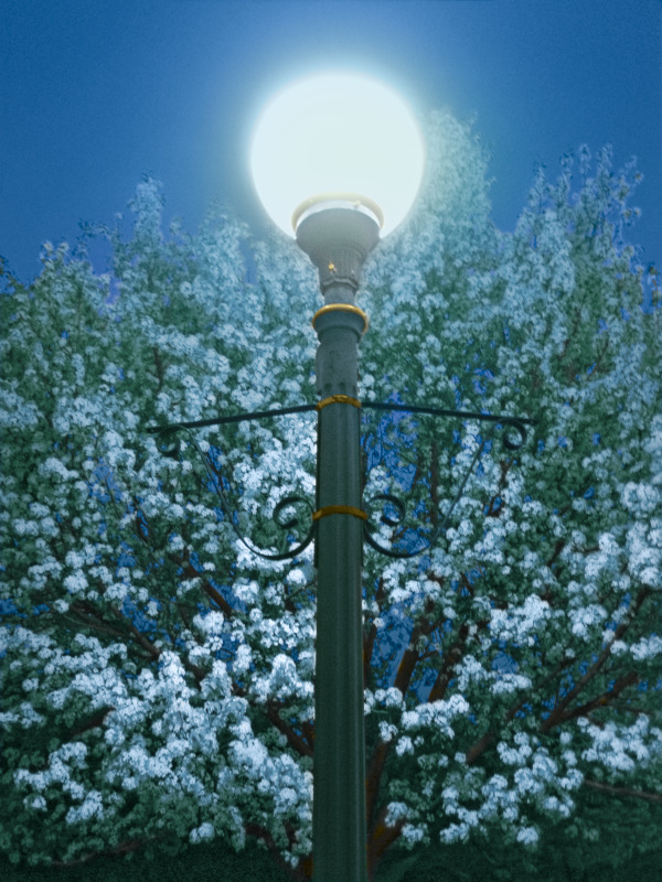
The photograph above shows one of the elegant old lamp posts in the Niagara Falls State Park that lit the way as we walked back to our hotel room. As already noted, the city of Niagara Falls, New York is in an state of long-term economic decline. Consequently the Niagara Falls urban landscape is filled with buildings and other architectural elements from an earlier era.
Processing note: I liked the the lamp post and the composition, but the colors in the original camera jpeg were unpleasant. So I made a black and white rendering and colorized it. My goal was to use color to emphasize the mass of flowers climbing up behind the post, and also make the image look like it was taken in the evening, which in fact it was. I'm still debating the success or failure of my efforts. In retrospect, I think the branches look like they are carrying snow instead of blossoms. Even so, I like the recolorized image quite a lot.
Viewing note: I was surprised at how really bad the colors in this picture looked when viewed with a browser that doesn't provide for color-managed browsing.


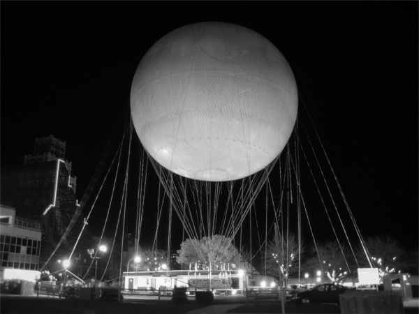
The two photographs above shows the Flight of Angels tethered hot air balloon in the air and on the ground. Sadly, Flight of Angels has since ceased operations. When it was still in operation (and winds permitting), the Flight of Angels balloon would float out over the Falls, giving you a silent view of the Falls from the air. Today you can take a helicopter ride over the Falls, but helicopters are noisy and they vibrate
As we walked around Niagara Falls it never occurred to us that the big balloon in the air was actually carrying people. I took a lot of pictures of that balloon because I was intrigued by how the sunlight hitting the balloon produced the same crescent shape as the sunlight hitting the moon (sort of an Ah Hah! moment — sun lighting up the moon, sun lighting up the balloon, of course it's the same shape).

The photograph above shows a view of the bar at the Niagara Falls Hard Rock Cafe. After a day of walking about viewing and photographing the Falls, we had dinner and then stopped at the Hard Rock Cafe, which was nearly deserted. The drinks were really good, so we treated ourselves to a second drink and then wended our way back to the hotel, on foot, of course. You don't need a car on either side of the Niagara River unless you want to leave the vicinity of the Falls tourist districts. You can even walk from one side of Niagara Falls to the other along pedestrian lanes on the Rainbow Bridge, these days assuming, of course, that you have a proper passport. You also need 50 cents, Canadian or American.

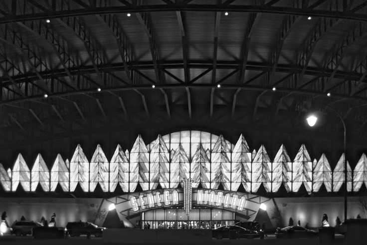
The photograph above shows the front entryway to the Seneca Niagara Casino. The Casino is built on the location of the former Niagara Falls Convention Center, which was a previous failed attempt to invigorate the local economy. What the photograph doesn't show is the 26-story Seneca Niagara Hotel behind the casino. So Niagara Falls, New York does have one modern skyscraper, "the first addition to the city's skyline" since the 1920s.
The Seneca Niagara Casino and Hotel are run tax-free and have been a financial success, though recent year-over-year returns have fallen. Seneca Niagara hasn't contributed as much to the local economy and city coffers as was anticipated by the city council, partly because funds have been tied up in a gigantic dispute between the Western New York Indian casinos and the New York State government.
We had booked our room in advance at the Seneca Niagara Hotel, which is a fine hotel and also the largest hotel in Western New York. Next time we go to Niagara Falls, we plan to look for a room at one of the smaller, older hotels that are just as near to the Falls as the Seneca Niagara.
Many residents of New York's city of Niagara Falls are trying very hard to ensure that future development plans preserve and capitalize on the existing parkland and old world charm, rather than seeking the silver bullet that Seneca Niagara was supposed to be. Otherwise future visitors to Niagara Falls might eventually see long lines of skyscrapers leering at each other across both sides of the Niagara River.
The Ontario side of Niagara Falls
Just as on the New York side of Niagara Falls, on the Ontario side there are walking paths and lookout points that allow excellent views of the Falls. We spent some time exploring the bustling tourist district, which turned out to be filled with an array of generic (and very nice if you like that kind of thing) modern tourist attractions. Then we walked west (upstream) along the Niagara Gorge to the Horseshoe Falls lookout point, of course taking pictures along the way.
The basin of Canada's Horseshoe Falls is always filled with dense white mist that rises pretty high into the air. Photographically speaking, even on sunny days the mist obscures your view (and your camera's view) of the face of Horseshoe Falls and also flattens the dynamic range of your captured images.

The photograph above was taken just downstream from Horseshoe Falls, looking through the mist and across the Niagara Gorge to the far side of Horseshoe Falls. There's photographic magic in that mist, though none of my photographs did it justice.

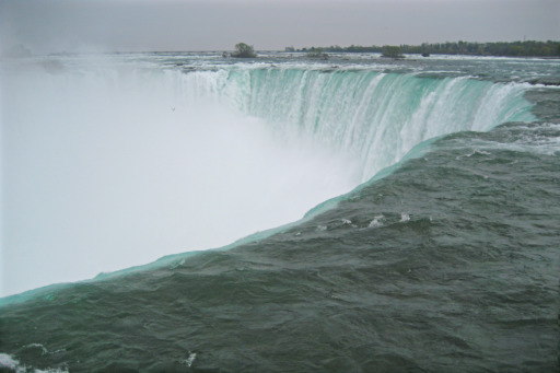
The photograph above shows the view looking across the top of Horseshoe Falls. The photograph was taken at the Horseshoe Falls lookout point, which puts you close enough to the water that you can practically reach out and touch it. The mist in the Horseshoe Falls basin piles up pretty heavily. The above photograph shows only a portion of the crest and the mist reaches considerably farther into the air than the photograph indicates.
The green water color is a "byproduct of the estimated 60 tonnes/minute of dissolved salts and "rock flour" (very finely ground rock) generated by the erosive force of the Niagara River itself." The large speck in the mist is actually a seagull. There's a bunch of smaller "seagull specks" that you probably can't see.

The photograph above shows a portion of the Horseshoe Falls crest. It was taken at the Horseshoe Falls lookout point, from the same spot as the previous photograph. If you refer back to the previous photograph you'll be able to pick out the exact portion of the crest that I pointed the camera at.
Ninety percent of the water from the Niagara River goes over the Horseshoe Falls, and as it goes over the crest, the water over Horseshoe Falls is upwards of ten feet deep.
My most vivid memory of Niagara Falls is the roar and the impression of sheer unmitigated power that is made by the massive amounts of water plunging over the crest and into the Gorge. Such things are not easy to capture with photographs, but I took a lot of photographs trying anyway, with the above photograph being my best effort.
Notes
Well, this is the end of my photographer's tour of Niagara Falls. If you made it this far, thanks! for reading and I hope I didn't bore you silly. Following are some notes you might or might not find useful:
Photographing scenes of natural beauty in an urbanized, industrialized world
With your eyes you can ignore whatever it is that you don't really want to see, but the camera is not so forgiving. So when photographing scenes of natural beauty, you need a plan for dealing with intruding elements from our increasingly urbanized and industrialized world. When faced with such intrusions (such as Canada's skyscrapers lining the Niagara Gorge), you can:
- Frame the shot to exclude what you don't want to see.
- Compose the shot to make the intruding elements look pretty; sometimes this requires reducing what you really want to photograph to the role of "scenic backdrop".
- Forget about pretty and instead try to document the unpleasant juxtaposition of what you do and don't want to see.
- If all else fails and you really want a pretty picture rather than a documentation of urban/industrial infringement upon nature, try removing the unwanted elements in post.
Camera and software
My digital darkroom is built on Gentoo Linux using free software. For processing the images in this essay I used digiKam to catalog and choose which images to include in the essay, and then processed the images using RawTherapee 4.2 (great for removing noise and vignetting from camera-generated jpegs) and high bit depth GIMP 2.9 from git, with an occasional foray into Krita 2.9 beta.
All the photographs in this essay were taken with the (then current, now quite dated) Canon SD600 Point and Shoot camera, which did not allow saving raw files to disk. If you plan on photographing the Falls, at least for your first foray you'll probably be happier if you take the minimum possible amount of camera equipment — a small camera with a moderate zoom lens will do nicely. Do take a camera that can shoot raw in case you want to give your own interpretation to the scenes you capture. In-camera-produced jpegs have sharpening artifacts baked in, plus crushed shadows and highlights; working with such files in post is a PIA.